


Bhubaneswar, a city where ancient temples meet modern urban planning, showcases a unique blend of heritage & rapid development, evolving into one of India’s leading smart cities
Kapilas Bhuyan
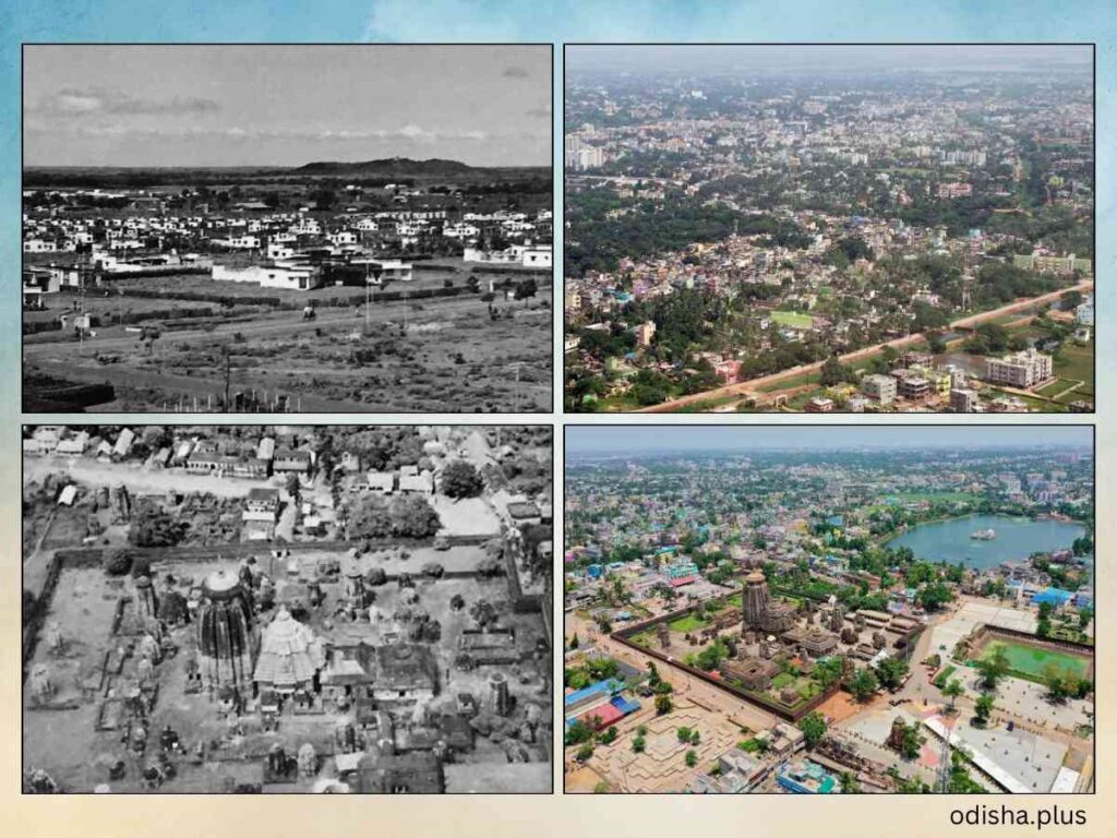
Here is the tale of two towns – one is traditional and old, and the other is fastest growing, modern and new. Yet, together they constitute a city, and today it’s called a smart city.
The old town has grown over more than a thousand years having a temple as the epicentre. The old town is also dotted with hundreds of small and miniature temples those are built from 7th century onwards.
Today, a visitor to the place will no doubt feel like as if witnessing a living museum.
However, the new town is built up only about 90 years ago with a well led-down plan and the intention of both towns supplementing to each other in adhering a semblance between them. So that the new town will inherit the pride of the old town, yet providing the modern facilities as might be required by the contemporary needs.
Yes, it is Bhubaneswar, the temple city having the Lord Lingaraj Temple in the old town where the phallus of Lord Shiva is being worshipped as the presiding deity of the place, traditionally known as Ekamra Kshetra. But today, it is part of a smart city. The skyline which once exuding the sacred temple tops and fluttering flags alongside the surrounding vegetation, now as part of a smart city superimposed with oddities of high risers, high mast neon illuminations, attention grabbing billboards and even skyward pointing mobile phone towers.
The smart city is growing both ways – vertically as well as horizontally. Until the end of the nineteen-eighties none was the trend – people were reluctant to buy flats of the housing schemes those were coming up in the outskirts of the town. Now a days, high-rise apartments are in the trend, and many people find it unaffordable to have one.
Today the capital city of Odisha is no doubt the fastest growing place. The price of land has become at least twenty times more in last two decades, though there is no genuine reason why it is so! However, people have been willing and, in a hurry, to buy a patch of land anywhere around within or even beyond 20 kms radius of the downtown. The city is growing even beyond that with a forthcoming plan of an outer ring-road expanding the radius to about 35 to 40 kms around the city.
Some people argue that since Bhubaneswar is a nice and peaceful town, most local Odia people and many non-Odia outsiders prefer to have a home here. Is Bhubaneswar really a peaceful town?
About six decades ago, the Govt. had been forcing its employees and businessmen to buy land and build houses and shops so that the city would grow in size. Today the growth is so fast that, the city spreads to its South-West, North-East and East to get Khurda, Cuttack and Pipili respectively under its ambit to become a metropolis within a span of last two decade. The visible gap between the twin cities Cuttack and Bhubaneswar even during the early 2000 is now bridged up by both residential apartments and business enterprises.
In those initial days, when the foundation stone of the new capital at Bhubaneswar was laid on 13 the April 1948 by Pt. Jawaharlal Neheru, the whole place of the new town was a vast barren land. Most of the Northern-Odisha politicians were in favour of having Cuttack as the capital of the state. However, the Southern politicians were in a pull for Rangailunda of erstwhile Ganjam district for the purpose. It was Dr. Harekrushna Mahtab, the then Chief Minister of Odisha (1946-1950) wanted Bhubaneswar to be the Headquarters of Governance, and the foundation stone for the purpose was laid down by Pt. Neheru.
However, Cuttack continued to be the capital and there was a kind of stalemate in Bhubaneswar becoming the headquarters. But it was when Dr. Mahatab was the Governor of Bombay (1955-56), manipulated the situation to make Bhubaneswar functional as the Headquarters of Governance.
Until very late up to early Nineteen-nineties many people had the wrong notion that Bhubaneswar was planned by Le Corbusier. The confusion had prevailed simply because both Bhubaneswar and Chandigarh were developed as two modern Indian cities at around the same time. But factually, Bhubaneswar was developed by a German Town Planner and Architect Otto H Koenigsberger (13 October 1908 – 3 January 1999), who had by then worked mainly in urban development planning in Africa, Asia and Latin America. He collaborated with the Goa-born architect Julius Vaz to develop Bhubaneswar as the new capital town of the Odisha state.
More often than not, until a few years ago when people used to refer to the Master Plan of Bhubaneswar, they normally meant to the plan that was developed by Koenigsberger. It’s needless to mention that the city of Bhubaneswar in its earliest form had been one of the very well planned cities of the country.
However, in 1953 Königsberger moved to London and became head of the Department of Development and Tropical Studies at the Architectural Association, which later became the Development Planning Unit of University College, London, where he worked as a professor until his retirement in 1978. (Courtesy: Wikipedia) And later in 1961 when Julius Vaz left Bhubaneswar, the structural aspect of the town had started becoming chaotic, to such an extent that today, when we look at the city’s skyline it seems as if it does not have any character of its own.
Looking at the prevalent temple architecture rampantly available in the old town of Bhubaneswar, both Koenigsberger and Vaz decided to structurally balance the look of the new town with that of the old one. Besides, Koenigsberger wanted the city to have self-sufficient units of human settlements. The hillock full of bears (Bhallu Pahad) at one end was decided to be the place where the Governer’s house would be built.
A straight road was drawn to connect the other end having an over bridge to give room for railway track – there shall be a major traffic array alongside of which there will be self-sufficient and independent units of localities – and that is evident even today when we find a market, a park, a playground and separate schools for boys and girls in every unit of Bhubaneswar located alongside that main road.
The numbers of units initially were limited to VI and the infrastructure was developed having a futuristic projection of 40,000 populations within a 5 k.m. radius. But by mid-sixties another 3 units were added, and by early seventies units were dropped for accommodating Nagars, and later on, Vihars having been suffixed as new nomenclature.
Unlike Sir Lutyens’ Delhi which is composed of circles, Bhubaneswar is composed of rectangle grills. Thus, one finds the vehicular movements on the roads at the outer peripheries of units, whereas the inside roads are virtually very peaceful without any traffic.
In order to maintain the semblance between the old and the new towns, both Koenisberger and Vaz had come up with structures having temple like tops; viz.; the main Market Building, the Capital Police Station, the Daily Market, the UP Schools in various units, the Unit I & II Girls High Schools, the Rabindra Mandap and the Red Building meant for the office of the R&B Department (popularly known as the Red Building), etc.
The Red Building is not red now and bereft of its unique identity as the Govt. has changed its colour to white and included it within the precinct of the State Secretariat since a long time. In fact the earthen reddish shade that was chosen to colour the buildings by the planners, were with the intention to make the town look bonded to the earth and exude a feeling of oldness as of the old town of Bhubaneswar. Thus, it could be well understood that the approach was more towards assimilating the two towns than creating any contrast.
The temple like structures of buildings is long forgotten now, only with the exception of the National Aluminum Company (NALCO), East Coast Railways headquarters and the Hotel Swosti Plaza, though are built very recently by the PSUs and private business ownrs, have retained the spirit of the town as intended by its original planners. Yes, the Govt. has retained the temple like tops of the recently built Kharavel Bhawan which is a saving grace.
Most of the Govt. buildings are found to be with impressive corridors. These corridors, besides being used as passages are also intended to protect the walls of the office rooms from the direct hit of the sunrays. For example, the corridors of the State Secretariat are found to be very wide and positioned facing the west, and thereby creating a vacuum space to hold the heat and protecting the walls from the direct hit of the rays of the afternoon sun.
It is believed that Julius Vaz had the understanding of the tropical weather, and therefore, had built the wide corridors so as to provide the administrators of the state a space to work comfortably, even in the absence of air conditioners during that time. But, today, we find most officers of high echelon of the administration including their political bosses seem to be oblivious of this architectural provision to tackle the summer heat and opt for air conditioners matching to their power positions.
The State Secretariat was built with vertical columns at its main entrance and spreading wings of administrative offices on both sides to exude all-inclusive uniqueness as the epicentre of power in the state. However, the recently built building of the Bhubaneswar-Cuttack Commissionerate of Police has undermined the intended spirit of the State Secretariat.
This monolithic and towering structure, largely adhering to the British architectural form surely outshines all other Govt. structures in the town and stands as if superior to all other structures, including the State Secretariat and the Assembly Hall. Even the newly built nearby Kharavela Bhawan looks much modest in comparison.
In those early phases, Bhubaneswar probably had very well-planned drainage system, however, due to lack of maintenance it all got damaged, particularly in the down town. On the other hand, the city encounters artificial floods as the ten natural drainage channels prevalent in the town are obstructed by illegal structures built on them. Despite being marked as the natural drainages in the Master Plan, why people are allowed to reclaim land and build houses right in the middle of the channels?
The Bhubaneswar Development Authority which is in charge of sanctioning the plans for building houses in the city, is found to be flouting its own rules to oblige the people in power positions and creating chaos. But things are improving a lot over last one decade or so as many correctional majors have been taking place to make Bhubaneswar one of the top smart cities of the country. In the meanwhile, the govt. is changed.
But the new govt. should give attention to continue the correctional trend. Besides widening the roads, the authorities should give extra attention as to how the vehicular traffic should be managed to avoid traffic jam. Additional infrastructures like foot overbridges, under ways and footpaths should be built for the safety of pedestrians. Awareness drive should be conducted for lane driving to avoid traffic jams.
Until now the city has been growing horizontally, but as the availability of land is on the decline, it’s time for the authorities to think of vertical growth of the city with multilayer vehicular traffic facilities.
Bhubaneswar is growing as a smart city at a very first rate, and if the growth rate continues at the same pace, it won’t be a wonder that within a short period of time a large number of people, locals as well as from the other parts of the country will prefer to come here to set up their homes.
(The author is a Senior Journalist, Writer, Art Critic & Curator and National Award-winning Filmmaker. Views expressed are personal.)


A Tale of Two Towns:
As the subject suggests, the contents lack information about the old town (Cuttack), while the new town has been extremely glorified. Contents about Cuttack could have been much more to justify the subject/topic.