


IMD forecasts a low-pressure area over the Bay of Bengal around October 24, with chances of cyclogenesis and possible impact on Odisha
OdishaPlus Bureau
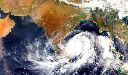
The India Meteorological Department (IMD) announced on Thursday that the first low-pressure area following the withdrawal of the monsoon is anticipated to develop over the Bay of Bengal around October 24.
The national weather forecasting agency indicated that most models suggest the formation of a low-pressure area over the southeast Bay of Bengal and the adjacent Andaman Sea, with expectations of further intensification and a west-northwest trajectory. It noted that conditions are favorable for cyclogenesis (the formation of a depression) over the Bay of Bengal in the upcoming week.
Manorama Mohanty, Director of the Bhubaneswar Meteorological Centre, stated, “We are diligently monitoring the expected weather system, and additional information regarding its intensity and path will be available in the coming days.”
As the system is projected to move west-northwest, meteorological experts are closely observing to determine whether it will bypass the country’s coastline and proceed towards Bangladesh.
Odisha, which is susceptible to natural disasters, has a significant history of experiencing cyclones that originate in the Bay of Bengal during October. The super cyclone of 1999, which struck Odisha on October 29, had a catastrophic effect on the state. Other cyclones in October, such as Phailin (2013), Hudhud (2014), Titli (2018), and Dana (2024), highlight the region’s vulnerability.
In the meantime, the regional meteorological office has reported that both night and day temperatures are expected to remain normal from October 17 to 23. However, night temperatures are predicted to be normal to above normal from October 24 to 30, while day temperatures are likely to stay normal during this period.